Satellite data reveal signs of widespread disturbance in peatlands across the Alps, study led by MENDELU scientists finds
16. 11. 2026
Peatlands are important stores of carbon and valuable hotspots for biodiversity, but many small peatlands in the European Alps are difficult to map and monitor. A new study led by researchers from the Faculty of Forestry and Wood Technology, MENDELU, combined satellite observations and terrain data to examine 590 peatlands across Austria, Germany and Switzerland. The results: The results showed that almost 86% of peatlands examined exhibited visible signs of disturbance, some of which can also be detected through satellite monitoring. The model can point to areas where field surveys, conservation and restoration efforts are most needed.
In the study, published in the Nature Portfolio journal Communications Earth & Environment, researchers from LDF MENDELU joined forces with colleague from the University of Göttingen. Led by Dr Marian Schönauer from the Department of Forest Protection and Wildlife Management, the team brought together expertise in forest ecology, geoinformatics and remote sensing to develop a harmonised approach for detecting and monitoring peatlands across the European Alps.
The researchers analysed 590 officially mapped peatlands across Austria, Germany and Switzerland. They combined optical data from Sentinel-2 satellites, radar observations from Sentinel-1, surface-temperature data from Landsat 8 and terrain metrics. The aim was to develop a model capable of identifying peatlands from using satellite data and comparing the results with existing maps. The quality was validated by the official peatland mappings. Most of the predictive information in the model developed came from optical Sentinel-2 data, particularly spectral information related to vegetation.
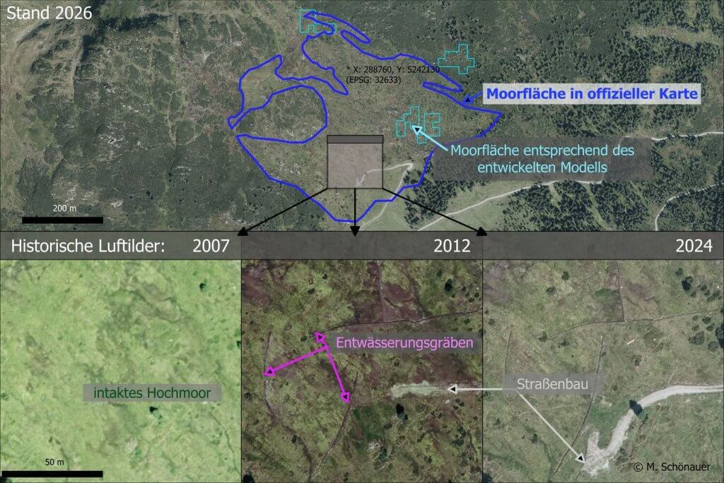
One of the most important findings emerged during the validation of model predictions with existing peatland mappings and high-resolution aerial imagery. Visible signs of disturbance were identified in 86% of the 590 reference peatlands. These disturbances included infrastructure such as roads and buildings, visible drainage ditches, agricultural use and forest encroachment. On sites with visible disturbances, the modelled peatland area was often much smaller compared to the official mapping. These differences however are useful rather than simply being modelling errors. If a site included in official maps no longer exhibits the expected characteristics in satellite data, this may indicate degradation. However, discrepancies may also result from inaccuracies or outdated information in the maps. Field verification is therefore essential to confirm the actual condition of the site.
Aerial photographs document the changes in an Alpine peatland in 2007, 2012, and 2024. They show the ongoing changes to the landscape and the degradation of the peatland ecosystem, due in part to human activity, photo Marian Schönauer
“Our aim is not to replace field surveys with satellite data. The approach can help us identify where existing maps and current conditions no longer agree and therefore where field verification is most urgently needed. This is particularly valuable in the Alps, where many peatlands are small, scattered and difficult to access,” said Dr Marian Schönauer.
The research also involved PhD student Elizaveta Avoiani from the Department of Forest Management and Applied Geoinformatics, for whom co-authorship represents an important early-career research achievement. Her work contributed geoinformatics expertise to the interdisciplinary approach developed in the study.
“An important next step will be to verify the model predictions and, in particular, model-mapping discrepancies in the field. Yet we are already confident that the developed approach gives us the possibility to monitor large areas for peatlands, or identify specific sites where field verification is most valuable. This could be particularly useful in mountainous regions, where access to field sites is difficult and monitoring opportunities are limited.,” mentioned Elizaveta Avoiani.
A continuous cycle of satellite-based monitoring, targeted field checks and map updates could help authorities direct limited conservation and restoration resources towards peatlands undergoing the greatest ecological change.
Citation: Schönauer, M., Avoiani, E., Drollinger, S. et al. Peatlands mapped across the European Alps with a harmonised multi-sensor workflow show widespread degradation. Commun Earth Environ (2026). https://doi.org/10.1038/s43247-026-04036-3
Contacts for more information: Dr. Marian Schönauer, Department of Forest Protection and Wildlife Management, Faculty of Forestry and Wood Technology, MENDELU, marian.schoenauer@mendelu.cz
Elizaveta Avoiani, MSc. Department of Forest Management and Applied Geoinformatics, Faculty of Forestry and Wood Technology, MENDELU, elizaveta.avoiani@mendelu.cz
photo: Simon Drollinger; Well-preserved peatlands in the European Alps
This publication received funding from the European Union’s Horizon Europe project ERA Chair: Striving for Excellence in the Forest Ecosystem Research (EXCELLENTIA) (Grant Agreement No. 101087262).
Views and opinions expressed are, however, those of the author(s) only and do not necessarily reflect those of the European Union or European Research Executive Agency (REA). Neither the European Union nor the granting authority can be held responsible for them.
We work with cookies. Why? We analyse traffic and events on the website so that we can continually improve it. We also need cookies to provide social media features and to customise the content of ads. With consent, we may also pass some personal information to marketing platforms for marketing purposes.
About Cookies
Cookies are small text files in which websites can store information about your activity on the website and user preferences. They are used, for example, to make the browser remember your login, the consent settings in the cookie bar and, with your consent, various marketing and analytical information.
Necessary
These cookies ensure the basic technical functionality of the website, are necessary for the proper functioning of this website and are always active.
Analytical
We use third-party tools to track traffic. According to Google Analytics settings, personal data may also be sent.
Preferential
They store your personal settings, such as the language in which information is displayed, or allow you to offer content tailored to your needs.
Marketing
We are using third-part marketing cookies and your personal data to show you content customized to what you have viewed on our website. The content can be viewed elsewhere on the Internet. You can disagree with using of our marketing cookies but it will not reduce the extent of advertising offers you see, you will only see more of uninteresting and irrelevant ad to you.